Task Group Water

Scientific and Technological Results


During the first project phase, the work of the task group “Water” focused on the development of scientific methods, models and tools for the monitoring and implementation of water resources conservation and efficiency. In this sense, products and impacts so far refer to: 

  • development of new and adaption of well-established methods
  • implementation and dissemination of these methods
  • assessment strategies for relevant input data
  • processed model output data as a foundation for decision making
  • transfer of achieved knowledge and methods to relevant Chinese partners and stake holders (“human capital development”).

Scientific impact is foremost seen in knowledge transfer and capacity building in the local scientific community, responsible experts and stakeholders. With the start of subproject three, this focus will shift considerably towards practical utilization of the data and model components for interested parties from politics and business. Constituting a crucial basis, the scientific and technological results and impacts achieved so far include:


Assessment of the hydrological state

Building on the results of several field campaigns carried out between 2008 and 2010, the measures for sensing the hydrologic state were refined and, in particular methods for robust estimation of field-scale near-surface soil moisture content using Ground-Penetrating Radar (GPR), were further developed. Since these measures include a concept for continuous monitoring of characteristic sites with GPR, the Chinese partners from XIEG recently bought their own GPR measurement system.

Based on a series of small workshops and lectures given by Patrick Klenk this could then be put into operation in spring 2010 during the first field campaign of the RECAST Urumqi water group. During the first field campaign (March / April 2010), in cooperation with XIEG, different measurement sites were characterized (for a map of the investigated area, see figure on the left). A first series of measurements were carried out with the field campaign results and other acquired data being jointly evaluated. At multiple sites in a semi-desert environment, GPR methods were successfully applied to the monitoring of seasonal changes and their influence on near-surface soil moisture content.

Map providing an overview of the measurement points at which the distribution of surface water content was determined during a field trip in Spring 2010 using a georadar and gravimetric methods. The area of investigation is located around 50 km northeast from the citycentre of Urumqi.                                              Map source: google earth; editing: P. Klenk


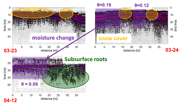
One example of such a multi-temporal measurement is shown on the right. Three radargrams acquired along the same profile at different dates show the influence of changing conditions (soil moisture content depletion). Since these measures include a concept for continuous monitoring of characteristic sites with GPR, the Chinese partners from XIEG recently bought their own GPR measurement system. Based on a series of small workshops and lectures given by Patrick Klenk it was sub sequentially put into operation during the first field campaign of the RECAST Urumqi water group in spring 2010.


Data acquisition and hydrological modeling

  • Compilation of general information and basic input data for the descriptive model (hydrology, soil, geology, vegetation, water consumption and quality, water sources and their distribution in cooperation with Yunyun WU (WAB))
  • Household questionnaire (conducted by TG Materials, project partners at IUWA and XJAEPS): Preparation of a survey on water consumption, wastewater and water usage efficiency in households, preliminary evaluation of the results
  • Land use and cover (LUC) data sets: Evaluation of satellite imagery, study on the vegetation cover and land use classifications as a preparation for the hydrological modeling for Urumqi and Midong to substitute missing and unavailable data (see figure below and Bachelor Thesis Brohmeyer 2011)  ( Bachelor-Arbeit Brohmeyer 2011)
 

  • Analysis of climate trends and glacial changes in the Urumqi region      
    • Multi-temporal detection of glacial changes in eastern Tian Shan (AR Xinjiang, China) in the context of climate change Bachelor-Arbeit J. Fuchs 2011
    • Evaluation of  temperature and precipitation data from 15 climate stations around Urumqi (AR Xinjiang, China) Bachelor-Arbeit N. Barth 2011
  • Hydrological modelling for Urumqi:
    • Study on the urban hydrological system by Prof. Huifang JIANG: Black-Box­ Modelling for the Waterways in Urumqi, Basis and Starting Point for the Modelling in the Catchment Area
    • Preliminary estimation and calculation of the catchment area and waterways (see above, top right)
    • Design of the decision support system for water management and adapted using the available data to the specific needs of the users

Possible Implementation Projects and Cooperation with the other Task Groups

  • Report on the Hedong Sewage Plant and the reuse of waste water for irrigation (DAAD scholar Dr. Ping CHEN at the Department of Geography)
  • Report “LCA and possibilities for water management“, Summary of the results of the joint workshop, “Presentation and illustration of environmental management instruments (methods / tools)“ with the "Waste" und "Energy" task groups
  • "An Eco-profile of the ZhongTai Chemical Company, Urumqi – Modelling and material and energy flows and Analysis of Potential Energy and Resource Savings" by Li NIU, ifeu GmbH (TG Energy): Analysis of the results with respect to water use and possible reusage


Capacity building - development of specialist expertise

As formulated in the proposal, one of the central aims of the project is to train and support our Chinese partners in the implementation of common methods and instruments and also in the collection of data in order to (i) gain access to data that could not directly be collected by the German side, (ii) ensure that the changes taking place in the area of investigation are effectively monitored and (iii) to ensure that the established methods are being used. With respect to the hydrological modelling and the related decision support system, information and training workshops will be held for the responsible decision-makers. The following measures are seen as a way to (i) build trust between the project partners, (ii) enable joint learning and (iii) draw attention to the research and implementation areas.

  • A lecture series for research and master students at the XIEG on methods of applied geophysics was run in early 2010, with a special focus on the collection and analysis of georadar data, as well as the use of related electromagnetic methods such as time-domain reflectometry (TDR) to determine groundwater content.
  • Training of the Chinese partners on the use of recently developed GPR devices during the field trip in early 2010 (see photo, left).
  • This training programme will allow the partners from the XIEG to collect data independently; further exciting research results are expected.
  • Following the field trip, the German and Chinese sides are currently in the process of analysing and interpreting the collected data. This increases the ability of partners to analyse data.
  • An extended research stay for the DAAD scholar Dr. Ping CHEN in Heidelberg was organised and funded from the 10th of October 2009 to the 10th of January 2010. The focus of his research lies primarily in the comparison of the treatment of wastewater and wastewater standards in Germany and China.