 Wissenschaftliche Arbeiten
Franziska Brohmeyer
|
Ruprecht-Karls-Universität Heidelberg Geographisches Institut |
Heidelberg University |
海德堡大学 |
Urumqi, the capital of the Uyghur Autonomous Region Xinjiang in the Northwest of China, has made an enormous development during the last 50 years. Despite water scarcity the region has experienced a steady growth in population since the foundation of the People’s Republic of China in 1949. Since the 1970ies, by onset of industrialization, Urumqi is also booming rapidly in an industrial and economic way. So the greater area of Urumqi developed from a small city with less than 100.000 inhabitants to a megacity with about 4.5 million inhabitants within a few years (FRICKE et al. 2009, S. 62). Observable consequences of described developments are changes in land use. An effective method to monitor environmental changes over a long time period can be remote sensing. Using a supervised classification of landsat-satellite images the status of land use in 1975 and 2007 are compared and findings are visualized in two thematic maps. By estimating areas of the individual land use classes the transformations between the two years can be registered quantitatively and compared. Remarkably urban (sealed) areas and the water covered areas have spread. In 1975 the sealed area corresponded to 84,57 km² whilst in 2007 it was enlarged to an area of 765,68 km², which corresponds to a factor of 9. Through the growth of population the urban area has enlarged in the initial centre of Urumqi and also in the western deltas the settlement area has extended remarkably. Due to the expansion of the city and the increased demand of industrial locations the agriculture was constantly edged out to more inhospitable regions, where irrigation is essential. Thereby the existing irrigation plants were enlarged and new water reservoirs has been built on the transition region to the desert.
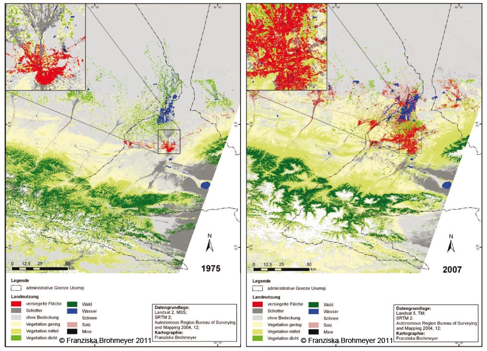
Abbildung: Klassifikation der Landnutzung in der Region Urumqi für die Jahre 1975 und 2007


